Pix4D is an image processing software, which is obtained as a result of mapping with drones and mobile devices. Through the use of state-of-the-art algorithms and advanced photogrammetric processing techniques, it generates point clouds, digital surface and orthomosaic models of very high detail that are used in the field of photogrammetry. It also has a line of data capture devices, including cameras and sensors that complement the software. Pix4D is an extremely complete and transversal option for all industries in the market that require highly detailed and precise data and information. Next, we explain how you can get the best out of it.
When is Pix4D used?
Pix4D has multiple applications aimed at providing specific solutions in specialized fields, such as:
Photogrammetric survey and cartography of very high detail
Through aerial inspection and photogrammetry with drones, 3D models and maps are produced with the purpose of expanding the understanding of your area of interest and simplifying procedures, generating greater productivity and reducing operating costs.
Agriculture
The use of drones to monitor crop fields through the collection of multispectral images is oriented, as mentioned by the general director of Pix4D, “to develop new methods and techniques of image analysis to promote sustainable agriculture, protect the natural resources and the livelihoods of future generations. Pix4D is focused on three specific points: research and development, agricultural management and sustainability. With Pix4D the mapping of agricultural fields can be used, among other things, to carry out the early identification of pests and pests, the planning of the use of fertilizers, the protection of crops and the application of various inputs in a targeted manner.
Construction
Drone aerial imagery will allow you to easily map, measure, analyze and report on the progress of your construction projects. With Pix4D and the images obtained by our drones, topographic surveys, visual excavation records, volume measurement, detailed engineering work, among others, are carried out.
Inspection
Within the context of inspections and asset management, the advantages offered by Pix4D are the following: it provides safer and more reliable results through the use of drones, as well as streamlining visual inspections using only the necessary images thanks to an automatic extraction tool of essential information. It also has a professional flight application, PIX4Dscan, specialized in industrial inspection with predetermined functions whose purpose is to optimize and simplify processes.
Mining
Thanks to Pix4D’s 3D modeling and mapping capabilities, mining processes can be monitored and controlled efficiently and effectively, as well as supporting the monitoring of mine facilities and infrastructure. In the same way, this tool will help you reduce operational risk through the identification of geotechnical risks (rock collapses, water inflows, slope stability, among others), it provides facilities in the life cycle management of assets and supply chain.
Benefits and Applications of Pix4D
The main advantage of Pix4D is that the software creates “digital twins”, that is to say a digital replica, of any product or physical infrastructure from the images recorded by a drone or any other equipment. This enables advanced analysis, monitoring, and prediction of the status of a physical product or process.
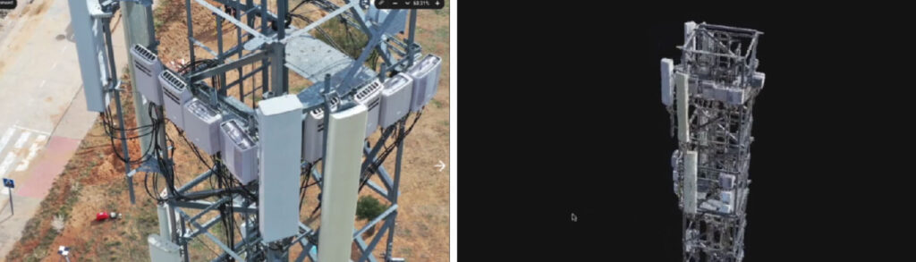
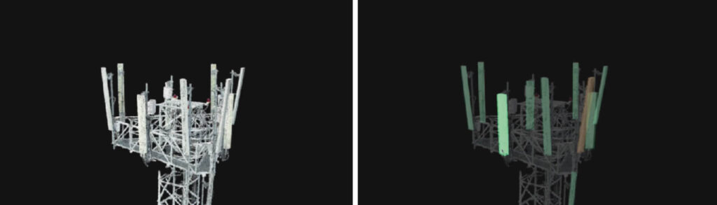
For example, in the telecommunications sector, this software is used to inspect and assess the conditions of a high voltage tower. It allows to identify problems with the transmission line, which can occur if a panel or cable is in poor condition, has rust, requires cleaning or another factor.
Another sector in which Pix4D is used is construction. An example is when rethinking a work, since on several occasions the execution area or terrain usually has different characteristics from those of the plan. In this sense, a solution is the collection of data with drones and the processing with the Pix4D software, which allow the generation of a digital twin of the area with greater precision and in less time.
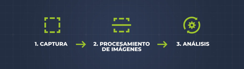
UAV Latam seeks to provide a comprehensive service to its clients, in the first instance it captures or collects images with industrial drones with extensive characteristics, then it processes these images, and now it also analyzes this data, which makes decision making easier. for the companies.
What programs and applications are included in the Pix4D software package?
The products offered by this software are used by prestigious companies, businesses, agencies and universities worldwide. As detailed on its website, these programs are:
3D mapping and modeling
• PIX4Dmapper: Photogrammetry software for professional drone mapping
• PIX4Dengine: Data-driven image capture for business
• PIX4Dfields: Field mapping and aerial analysis of crops for digital agriculture
• PIX4Dmatic: Oriented to large-scale photogrammetry
• PIX4Dreact: Rapid 2D mapping for emergency care and public safety
Cloud solutions
• PIX4Dcloud: Online platform for drone mapping, activity tracking and site documentation
Digital topography
• PIX4Dsurvey: The meeting point between photogrammetry and CAD
Inspection
• PIX4Dinspect: Serves to automate industrial inspection and asset management with drone images
Data capture applications
• PIX4Dcapture: Glide, Fly and Image Mobile App Optimized for Professional Drone Mapping
• PIX4Dcatch: 3D terrestrial capture app for photogrammetry solutions
• PIX4Dscan: Professional drone flight app for optimal inspection
How to get a Pix4D specialist?
If you are looking for a Pix4D specialist for a project, we recommend working with UAV Latam. We are specialists in the use of Pix4D and photography with Drones for industrial and cartography projects, and we can meet the specific needs of your company.